Rebuilding for resilience: UBC Engineering shares observations and learnings from recent BC storms
The storms that pummelled British Columbia in November 2021 had catastrophic impacts on infrastructure, communities and individuals. Leading researchers from Civil and Geological Engineering at the University of British Columbia came together for a technical panel in mid-December to share insights on managing the impacts of natural disasters on infrastructure such as highways, bridges, pipelines, dikes and rail lines. Among the topics discussed:
How can we improve our knowledge of weak spots in our infrastructure?
What data-driven tools and strategies will we need to rebuild in a way that’s more resilient to extreme weather events?
Steven Weijs, an Assistant Professor of Hydrotechnical Engineering, drew connections between November’s landslides and floods and the wildfires that ravaged BC communities in the summer of 2021. He spoke of Merritt’s 7,000 residents, who were evacuated in the summer due to wildfire threats and then forced to flee again in November from flooding.
“A large part of the catchment area had been affected by wildfire burns, which caused faster water runoff with less infiltration into the soil,” said Dr. Weijs. His preliminary analysis indicates the resulting flood may be a one-in-2,000-year event, yet as Dr. Weijs and others noted, climate change impacts will make these extreme weather events far more common.
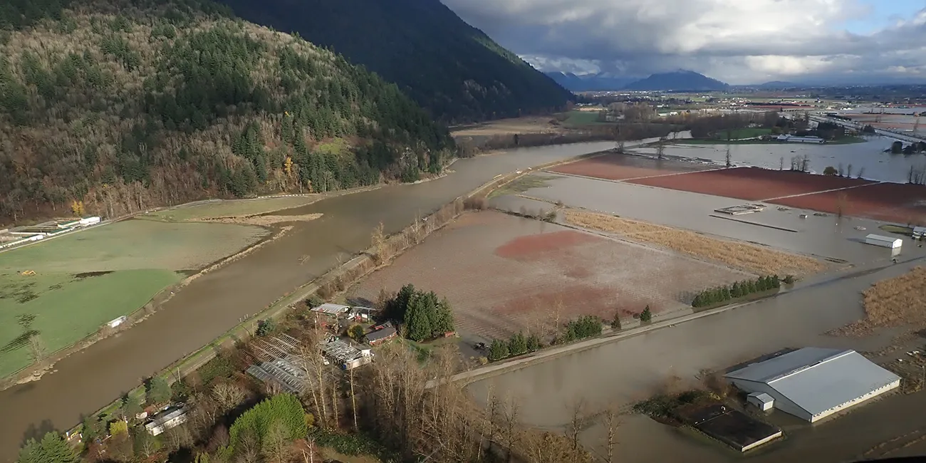
The torrential rain led to landslides and debris flows that severely damaged highways, destroyed bridges and shut down pipelines. Being able to predict where future debris flows are likely to occur will guide rebuilding efforts – and that requires collecting significant amounts of data to build predictive decision-making models.

Scott McDougall, an Assistant Professor of Geological Engineering, spoke about how state-of-the-art field mapping methods, including drones equipped with laser scanners, can be used to collect valuable data at sites of interest across the province. Researchers are currently using this data to develop predictive models for risk assessments of steep creek channels and other areas prone to landslides.
“These models give us information about debris flow paths and velocities, which can be used to design mitigation measures,” he said, noting that these measures are already in place in high-risk areas along the Sea-to-Sky Highway between Vancouver and Whistler. Decision-makers can use these models to identify where to invest in higher-cost solutions, with areas where multiple types of infrastructure converge being the highest priority.
Jonathan Fannin, a Professor of Geotechnical Engineering, touched on the challenges of designing, building and maintaining dike systems like those meant to protect the Sumas Prairie from floodwaters. The research and lab testing being done at UBC can inform reconstruction efforts, as can lessons learned in other jurisdictions about the processes that lead to breach and failure, including deterioration and internal and external erosion. “Managing risk and making decisions in the face of uncertainty is always a complex undertaking”, said Fannin, making it imperative that reconstruction efforts use “tools to make risk-based decisions that address appreciation for case precedent and international approaches to managing risk.”
With climate change bringing an increase in extreme weather events, we simply must learn from the events of 2021 so that we can act quickly and decisively to protect people and infrastructure.
Dr. Fannin advocated for a “step change in our warning systems” so that we can respond when extreme weather has the potential to cause flooding and landslides. He noted that in some jurisdictions of the world – like Hong Kong and Rio de Janeiro – landslide warning systems are used to protect people, for example with advice to stay home or remain in safe shelter when heavy rainfall is expected to trigger landslides.
Associate Professor of Transportation Engineering, Amy Kim, reiterated the value of protecting critical infrastructure by restricting movement to essential travel only ahead of extreme meteorological events, and being better prepared with rerouting options.
“We need our transportation network to be more resilient and adaptive to these challenges on our doorstep,” says Dr. Amy Kim. “In building transportation resilience against extreme weather… we reduce the severity and frequency of physical risk through design.”
Integrated approaches are crucial. Dharma Wijewickreme, Professor of Geotechnical Engineering, identified the value of an integrated approach to infrastructure management as a way to minimize risk. “We need to look at all the infrastructure systems as lifelines and pull together to look at it as one problem,” he said. “Many stakeholders share an interest in the same area and there is value in an integrated risk management approach at places at higher risk.”
It is clear that we will be addressing the legacy of the 2021 wildfires and floods for years to come. And if we are serious about building more adaptable and resilient infrastructure and communities, we need to take a coordinated approach to risk management. As Dr. Fannin said, “We need to anticipate events coming, issue warnings and co-ordinate across a series of disciplinary areas.” It’s by working together and sharing knowledge today that we’ll be prepared for natural disasters tomorrow.
Event summary produced by Lynn Sully on behalf of UBC Applied Science.
Missed the live event or would like to view it again? A recording is now available on UBC Engineering’s YouTube channel.
View the event's slide presentation.